
New York State has made available all of it's Orthoimagery via a "WMS Layer" (Web Mapping Service). This should prevent everyone from having to download NYS Orthos for each project. It's slow, but not terrible.
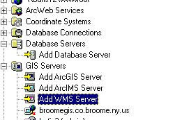
Open ArcCatalog, and "GIS Servers". Double click "Add WMS Server"
 Enter this URL: (you DO need the question mark at the end)
http://gisdata.usgs.gov/wmsconnector/com.esri.wms.Esrimap/USGS_EDC_Ortho_NYSDOP?
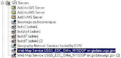
This will add a new web service for the Orthos. When you go into ArcMap, and click "Add Data", you will browse a list of images from different ortho programs (i.e. "WNY Color 2005" vs. ENY Color 2004"). You will need to know the section of the state you are looking for, as well as the year and image type (b&w / infrared / color)
Information on the photos collected each year can be found here:
http://www.nysgis.state.ny.us/gateway/orthoprogram/index.cfm
More information about the state WMS program can be found on this page
http://www.nysgis.state.ny.us/gateway/mg/webserv/ins_arc.html
It's not up and running 100% of the time, but seems pretty reliable.
No comments:
Post a Comment